Motivation
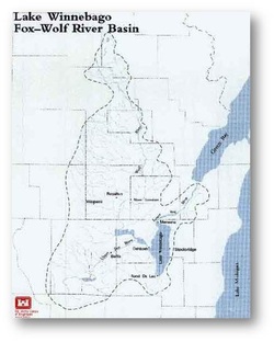
My motivation for the project was driven by that fact that there are fairly large populations living near Lake Winnebago. As shown on the map below, the cities of Appleton, Neenah, Menasha, Oshkosh, and Fond du Lac are all right along the Lake Winnebago's coast. Additional motivation came because I grew up in Fond du Lac so the area has additonal importance to me personally.

Coastal Environment
Lake Winnebago is the largest inland lake in Wisconsin. It covers an area of 206 square miles. It is 28 miles long, 10 miles wide, and 21 feet deep. The basin that it lies in contains the Fox River to the north and the Wolf River to the northwest.
There are also a number of human activities that are occurring on the lake. The Fox River has two dams on it right as it approaches Lake Winnebago. There is a privately owned dam in Neenah and a federally owned dam in Menasha. The dams are used to control the water level in Lake Winnebago. During the summer the water level must be kept at or above the height of the crest of the Menasha dam at 1.68 feet above the Oshkosh datum. Historically the Fox River has been a large source of hydroelectric power, however in recent years the amount of power being generated has gone down because there is not much money that can be made off of it. The region also has a large amount of paper production. Georgia-Pacific is located in Green Bay, Neenah has numerous paper companies operating out of it, and Kimberly-Clark is located in Kimberly. Finally, the lake is used for a large number of recreational activities. It is used for boating and fishing in the summer, and it is used for snowmobiling and ice fishing during the winter.
